Cleveland's New Form-Based Code
A user-friendly, predictable code to preserve and enhance Cleveland's neighborhoods
The Time is Right
An icon of the industrial age, Cleveland is pivoting to its new future: a green city on a blue lake. This direction has been set by the Mayor Frank G. Jackson Administration with the directive to leave no neighborhood behind. New buildings and new residents are rejuvenating long dormant portions of the city at an ever quickening pace. The rebuilding of these neighborhoods with modern housing, retail, office and industrial spaces have laid bare the need for new development policies and tools that support 21st century development trends. One of the development tools will be the strategic implementation of a new zoning code that fosters sustainable development patterns and addresses the challenges Cleveland faces in the 21st century.
A New Era
For more than 80 years, the Cleveland zoning code has served the city and its residents well. The zoning code responded to the challenges of its time by protecting and separating residential areas from the ill effects of neighboring factories, managing the reality of a populace in love with the automobile and providing for greenspace in a rapidly developing city. The city has moved on from some of these issues, some remain relevant and some challenges are entirely new. Through noble attempts to respond to changing patterns of development since its adoption in 1929, the zoning code has become layered and cumbersome to navigate. In many ways, the zoning code is at odds with the vision of what Cleveland will be in the 21st century.
A New Approach to Zoning
In response to the mixed signals being sent by the current zoning code, the Cleveland City Planning Commission has endeavored to realign its zoning regulations with this new vision. The goal is an entirely new zoning code that embodies the Mayor’s mantra of Health, Sustainability and Equity – this new approach to zoning is called Form-Based Code. The Cleveland Form-Based Code will be piloted in a few geographies to start – the City Planning Commission has identified sections of Detroit Shoreway/Cudell, Hough and the Opportunity Corridor as the first areas for implementation of this tool. If the pilot is successful, the new code will be expanded to cover more parts of the City as new neighborhood plans are adopted.
Selecting Detroit Shoreway/Cudell
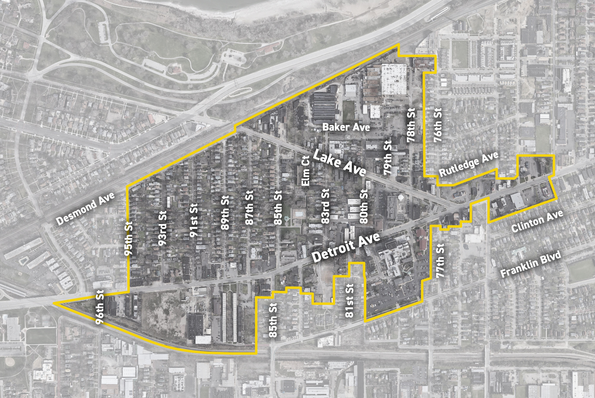
Detroit Shoreay/Cudell FBC pilot geography
So why was Detroit Shoreway/Cudell chosen as one of the pilot areas? With a relatively tight budget for a project of this scope the City Planning Commission had two main criteria when selecting the geographies. The first was to pick areas that were adjacent to other large investments, in this case Battery Park and the major improvements to Edgewater Park. The hope is that these investments spur additional investments in the nearby test geography. By mapping the new code in places that are expected to see new development in the very near future, the City can more quickly evaluate the codes effectiveness. Mapping the code where there may be less development pressure or even none at all wouldn't give planners enough opportunities to see how the code works in practice. New construction and substantial rehabs being proposed, permitted and built under the FBC is the only way to test the code.
The second criteria the City looked for was an area with a diverse typology of buildings and Uses. Regulating single family homes on residential streets require different types of zoning tools than mixed-use buildings on busy thoroughfares or manufacturing facilities in industrial areas. The Detroit Shoreway/Cudell geography has all of those conditions and more. It's what makes it such an interesting and loved neighborhood. The City Planning Commission needed to understand how to code for all of these different types of buildings and uses in order to expand the use of FBC in the future.
Public Input from Detroit Shoreway/Cudell Residents
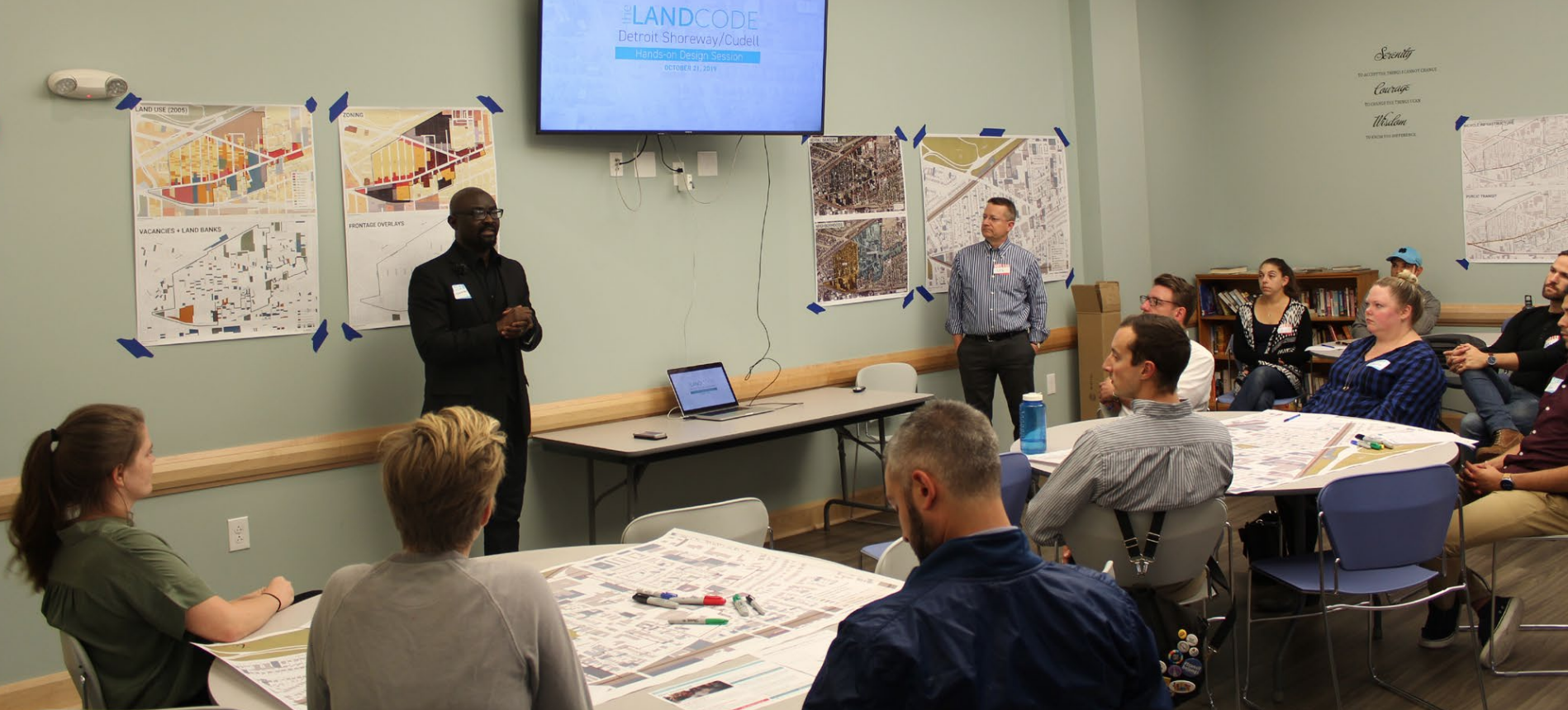
Public engagement meeting in Detroit Shoreway/ Cudell
The Form-Based Code relies on public input from the residents and business owners who know the neighborhood best. Well attended meetings and open drop-in opportunities were held during a week-long charrette that took place in the neighborhood.
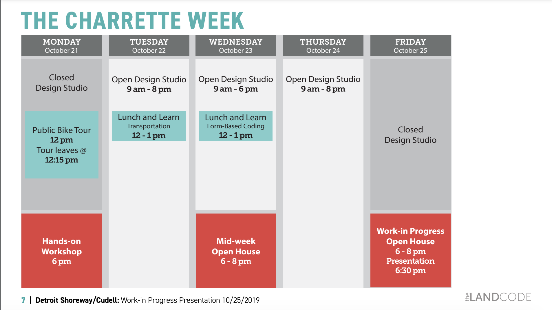
The Detroit Shoreway/Cudell Charrette week agenda
The week culminated with an open house at The Commons at West Village where the weeks work was presented. The entire presentation from that evening is available here. Key takeaways were:
- A consensus that the Lake/Detroit intersection should be more pedestrian friendly and new mixed use buildings of medium scale should flank it.
- Consensus that the residential interior of the neighborhood should permit a gentle density with a mix of residential building typologies that fit and complement the character and scale of the existing context.
- The character and uses in the industrial area north of Lake Ave is likely changing in the near future. There was consensus that higher density and taller buildings are acceptable in this area. There was also a desire to better connect this area to the Battery Park neighborhood with new streets, a trail or both.
With all of the input collected, the team set out to refine the map and create new Character Districts that reflect the vision from stakeholders.
The New Zoning Map
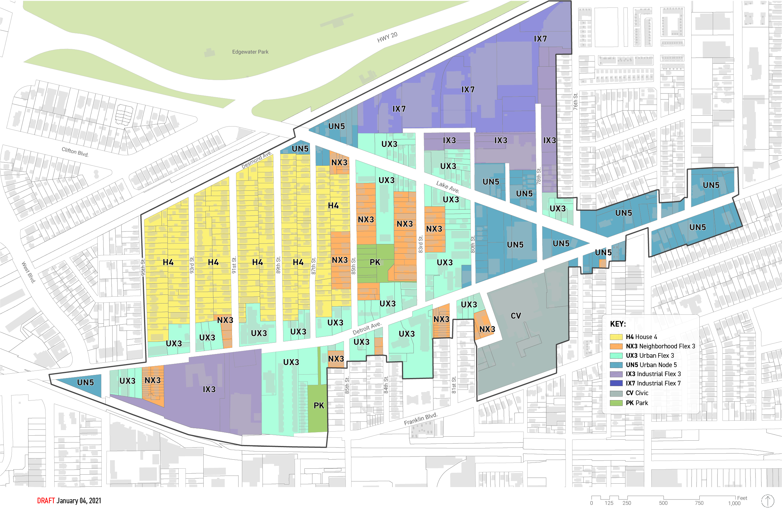
The new zoning map with legend
Based on the input from residents and stakeholders during the charrette week and further refinement by City Staff and the consultants, the above map reflects a future vision for the neighborhood while protecting the existing, beloved fabric that exists there today. The new form-based code will not require a property owner to change the existing use or appearance of their building in order to conform with the new code. Only future changes to the property would be subject to the new code.
Lets take a look at the legend and talk about how these new districts work.
Detroit Shoreway/Cudell Zoning legend
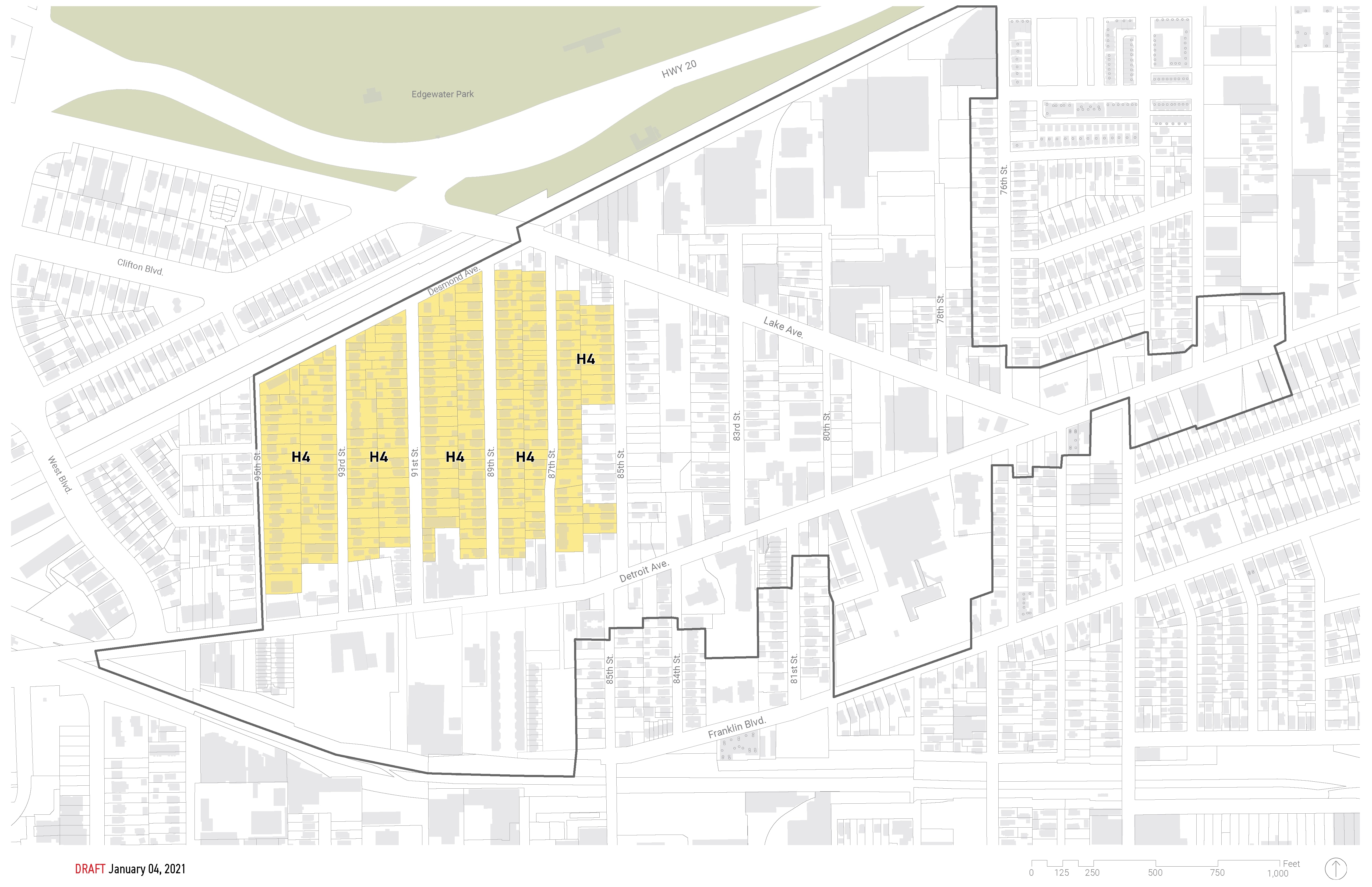
House 4 District shaded in Yellow
Let's start by exploring the House 4 District which is the primary residential district in the geography. Think of each district as its own 'mini-code' with its own set of permitted uses, height limits and setback requirements, etc. In the House 4 District up to four units are permitted on each lot. However the form that these units will take will look like the scale of the existing context. That is to say, new buildings in this district can be no more than 32' tall and not more than 2.5 stories. Minimum lot widths, requirements for street facing windows and doors and requirements for where parking is located will help new buildings feel like they fit into the neighborhood. Below is a video that explains in more detail how the requirements of the House 4 District work.
House District 4 (H4)
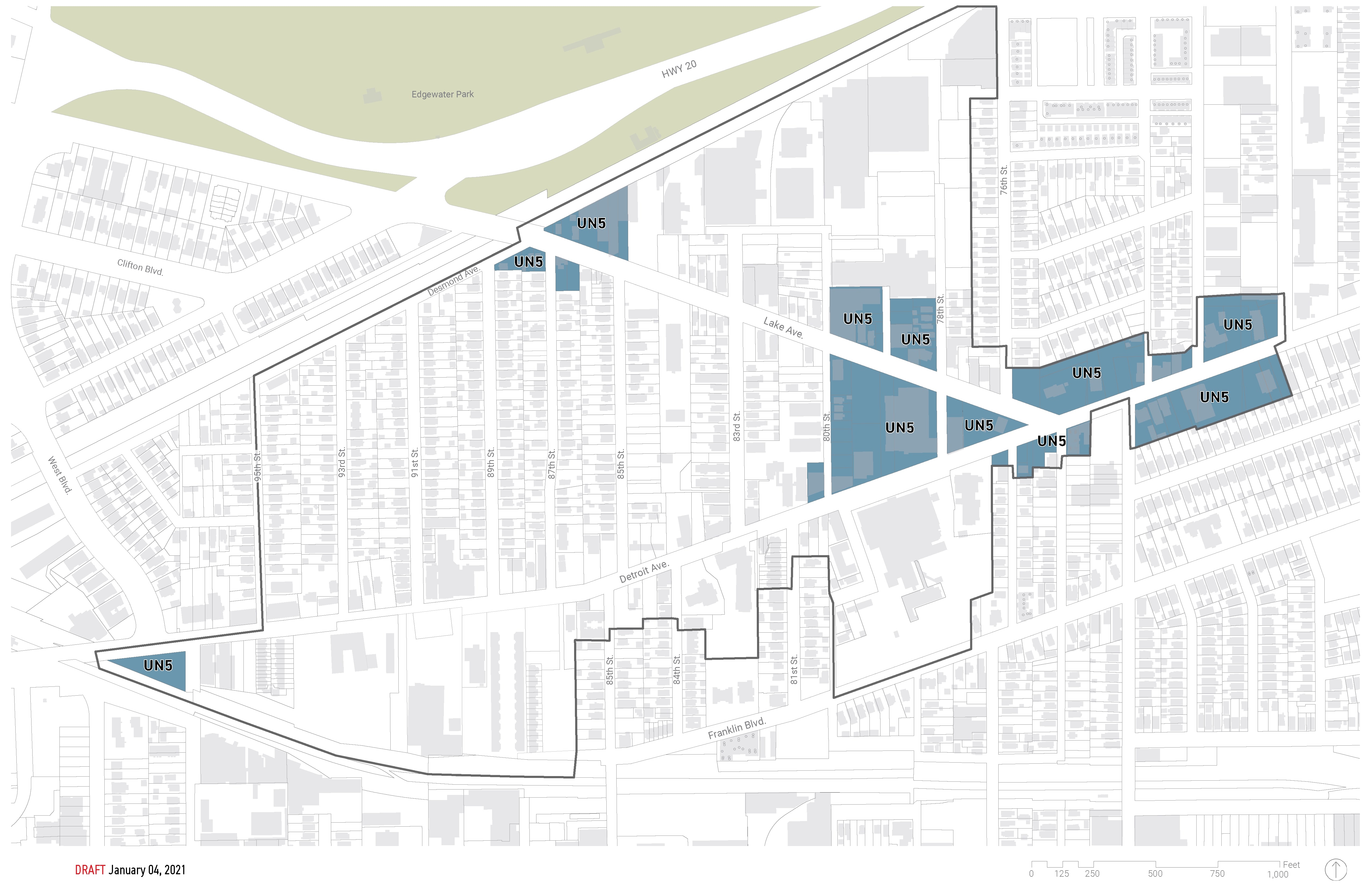
Urban Node 5 District depicted in Blue.
Next let's take a look at the Urban Node 5 (UN5) District. During the charrette week the sites that flank the Detroit/Lake intersection were a hotly discussed topic. There was a consensus that getting the zoning and the buildings on these sites correctly scaled and situated was critically important to the future of the neighborhood. With the closure of the Burger King and the vacant lots on the south side of Detroit, changes to this intersection may be coming faster than anyone thought. The UN5 reflects the vision of residents who wanted new buildings placed close to the street with active uses along the sidewalk and parking located either in the rear or in shared, district lots thoughtfully placed throughout the neighborhood. The UN5 does all of those things. The district calls for mixed-use buildings with minimal setbacks along the street and large amounts of transparent windows and doors along the sidewalk. Buildings here can be up to 5 stories tall. Below is a video that describes in more detail the UN5 District.
Urban Node 5 (UN5)
The next District is the Industrial Flex 7 (IX7). This area is designed for areas that have active manufacturing or light industrial uses but are transitioning to a mixed-use or even residential future. Any existing business may continue in perpetuity and the IX7 district permits a wide variety of light industrial uses, so new or expanded industrial uses are welcome. The district also permits commercial, office, makerspaces, artist studios, restaurants and residential uses.
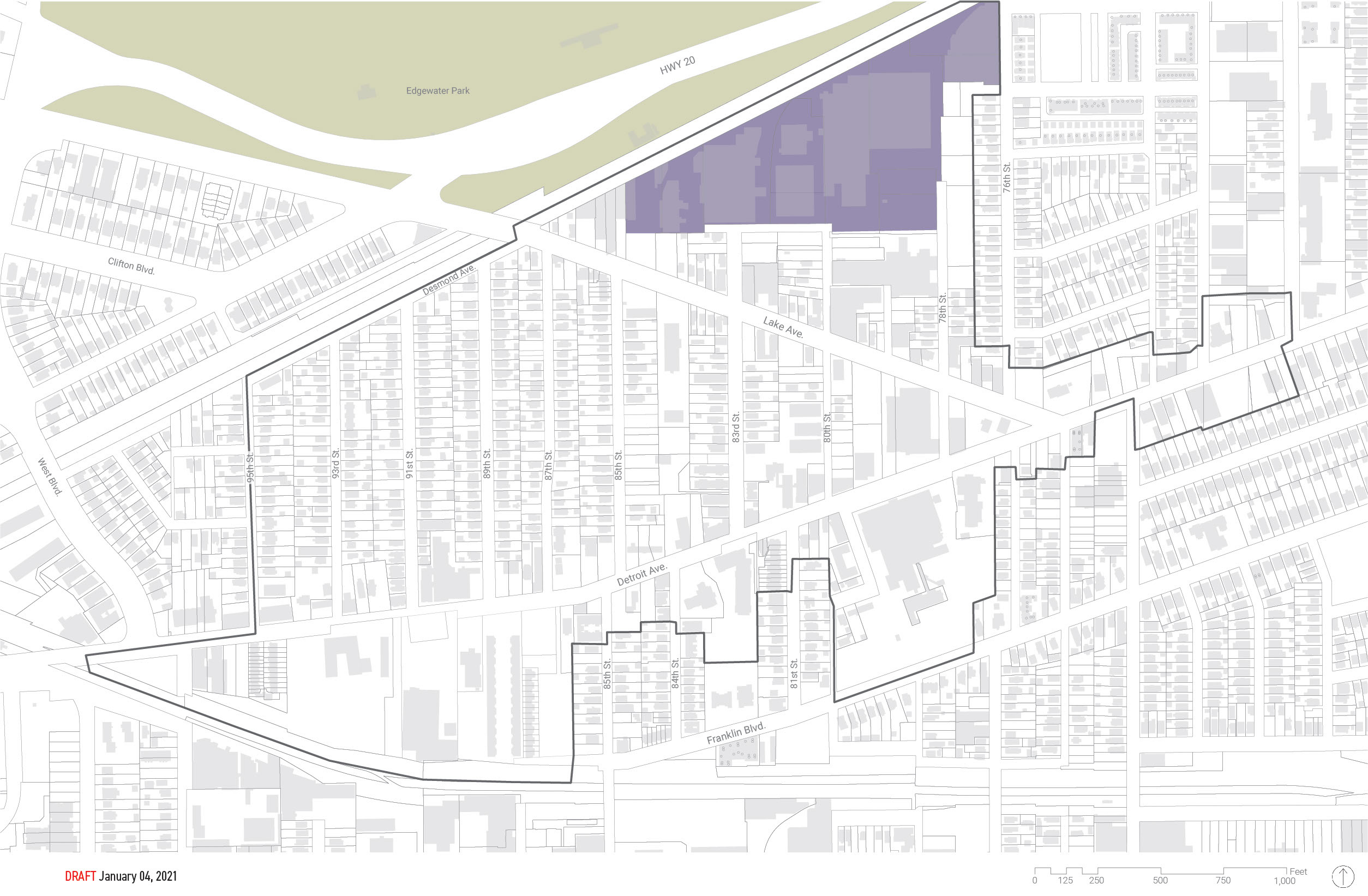
Industrial Flex 7
The remaining proposed districts for the Detroit Shoreway pilot area are essentially just variations of the ones discussed above. As the full code is rolled out, watch Thelandcode.com for the full text.
Design Review
While this section of the code is not fully built out just yet, there are a few important points to discuss. Compatibility and walkability are two of the main objectives of the new code. Because the new code is much more prescriptive than today's code as to how new and modified buildings should meet these goals, there's predicted to be a natural easing on the reliance of design review. This means, in the new code there will be less emphasis placed on design review with the goal of relying more heavily on the predictable, legislated requirements of the new code. However, as the new code gets tested over the coming years, it will be important to revisit our initial thinking on this topic and all provisions of the code. Meaning what is initially adopted may be modified or even overhauled in the future.
Parking
The United States has as many as two billion parking spots for only about 250 million cars. All that excess capacity has real world implications, and almost none of them are good. Excess stormwater runoff, increased vehicle miles traveled, and higher housing costs are just the tip of iceberg.
Check out the video below which summarizes findings from Donald Shoups book The High Cost of Free Parking. Shoup, a professor at UCLA, is the godfather of parking studies and has been a leading voice in the parking reform movement for decades.
The high cost of free parking
Following the data on parking reform is an important part of Cleveland's new code. And despite what you may think about there being some sort of science to parking requirements, there is no magic or even data to back up the ratios in Clevelands existing code. In fact, most ratios are just borrowed from other similar sized cities. And those ratios were borrowed from those city's peer cities in a time honored tradition that goes all the way back to Henry Ford and John D. Rockefeller just trying to sell more cars and gasoline.
Planners have adopted a veneer of professional language to justify the practice, but planning for parking is learned only on the job and it is more a political activity than a professional skill.
In 2017, Buffalo, a rust-belt City very similar to Cleveland, retired all of its parking minimums in favor of a market driven approach as part of its new form-based code. Developers are free to build the amount of parking that makes sense for their project based on factors like location, alternative transportation options, shared parking agreements or bank financing requirements. While this may seem radical, it's the exact same provision that Cleveland has had for its Central Business District (CBD) since 1971.
So what happened when Buffalo removed its parking requirements? The same thing thats happened in Clevelands CBD for the past 50 years. Developers built the amount of parking they needed to serve their customers and residents. A recently published study of 36 new developments in Buffalo found that new projects in areas that have multi-modal options did build less parking. In areas of the city that were more auto-dependent developers actually built more parking. However in either case, the developers were responding to actual demand rather than the pseudoscience of city mandated parking minimums.
Some key insights from the mixed-use development response:
- Rather than build parking, developers shared parking. Four mixed-use projects tracked by the research built zero parking spaces, and another project built 91 percent less parking than previously required. Instead of building new parking, these projects relied on shared parking networks, which enabled them to provide parking access without dedicating excess space to vehicle storage.
- Even new parking became shared parking. Only one mixed-use project tracked by the researchers built notably more spaces (17) than it would have needed to build under the old rules. But that was intentional, as this project had entered into a shared parking arrangement with an adjacent mixed-use project. The result was 71 fewer total spaces between the two sites than previously required.
- Transit-oriented development got a boost. Two mixed-use projects along the Main Street transit corridor created hundreds of units of student housing. The rise of two such projects — which the researchers describe as “previously uncommon in Buffalo” — suggest that the added cost of the old parking requirements had served as a deterrent to new development in transit-friendly areas.
- Adaptive reuse projects also became more viable. One small-scale mixed-use development near a light rail station rehabilitated an old structure into 10 new apartments with ground-floor retail space. Despite the close proximity to transit, the project wasn’t feasible under the old parking regime — which called for 10 spaces on the site — because the physical structure occupies nearly its entire parcel. With the new rules, it could finally move forward.
Simply put, by removing parking requirements, Buffalo unlocked the creation of more than 1,000 new homes and a vibrant array of transit-accessible businesses and restaurants — many of which might never have existed given the high cost of creating new parking.
Given the success of Buffalo's reform efforts and the growing body of data that shows that removing parking minimums has positive environmental, social and housing benefits Cleveland will be testing a no minimum solution in the three pilot areas where the form-based code is being mapped. It will serve as a test of the practice locally and results will be measured against developments that take place outside of the FBC areas to see how market forces and development demand change the outcomes.
When parking is proposed as part of a project, Cleveland's FBC will have requirements for where that parking is to be located on a lot and how it will be landscaped and screened. Additionally, in the Detroit Shoreway neighborhood, the City will be completing a comprehensive study of all on-street parking signage and options. We will seek to ensure that all public facilities are being used to their maximum efficiency. As part of that work, we'll also be looking at private parking options that may already be available and if they can be shared with new developments. Below is a map of existing parking in the FBC study area.
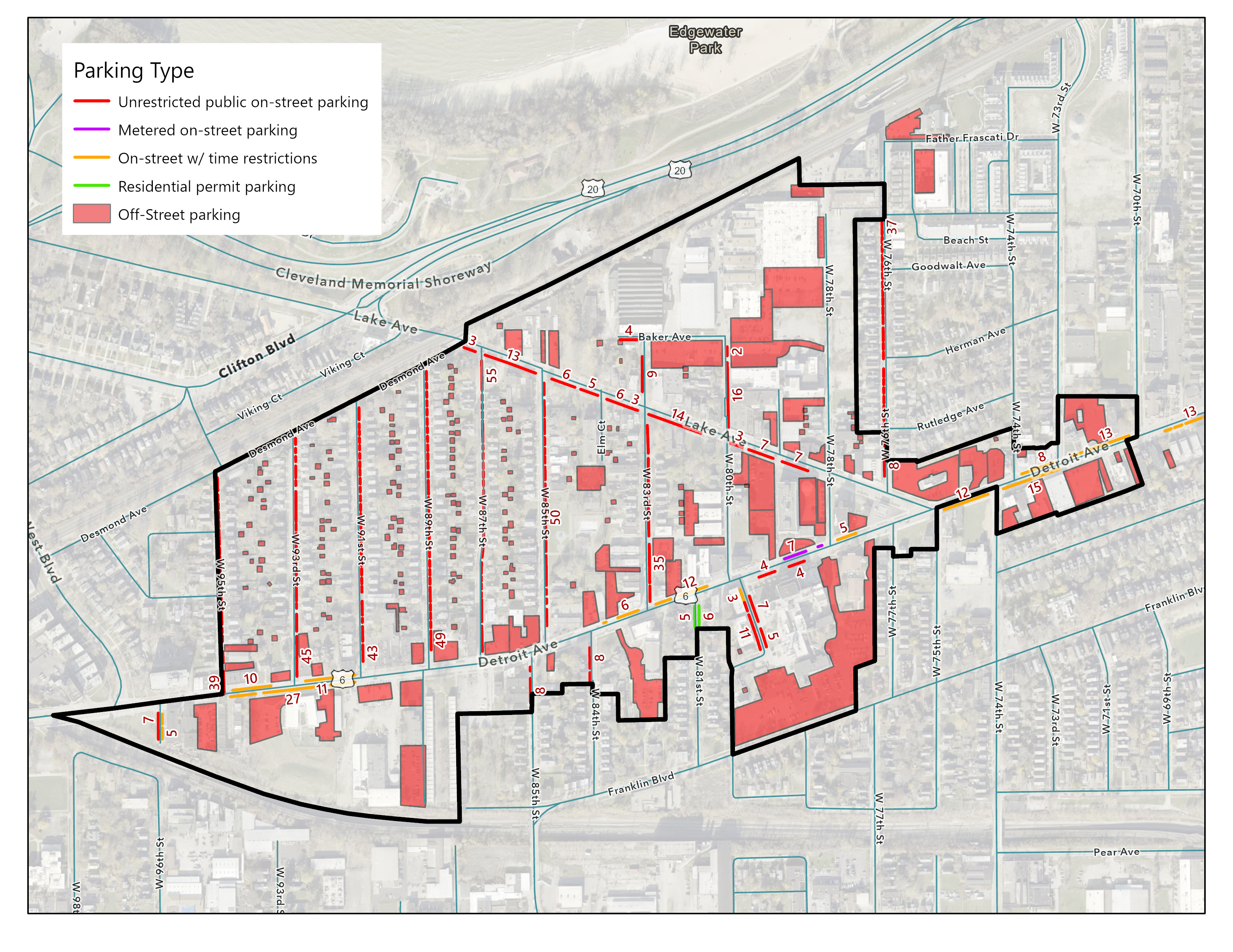
Existing parking availability study
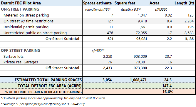
Estimated parking counts for the Study Area
Our thinking on parking needs to evolve with the data. The needs of people, not cars, should be the focus of our decision making on new developments. In Cleveland's new Form-Based Code, it will.
Next Steps
A final draft of the new code is anticipated to be complete this early this summer with public meetings of the Planning Commission slated to begin in late summer or early fall. It is the hope of the CPC that an adoption schedule will be complete by October of 2021.
Thank you
The honest input, thoughtful conversations and ambitious visioning for the future of this neighborhood by so many members of the community has led us to this point. We cannot say thank you enough. But our work isn't done yet. We hope you'll continue to be an active member of Cleveland's new Form-Based Code project. Follow along at Thelandcode.com.