 |
Land Use and Zoning |
|||||
A key component of the Connecting Cleveland 2020 Citywide Plan is its land use plan. “Land use” is a term planners use to describe the development of land. Some of the more common land use categories are Residential, Retail, Office, Industrial, Institutional and Recreation. For example, land occupied by houses would be classified as “Residential” with respect to land use; whereas land occupied by a school or a hospital would be classified as “Institutional.” (A list and description of the land use categories used in the Citywide Plan follows). Conventional Land Use Planning. Historically, land use was the key concept in community planning, because the classic comprehensive plan was, in essence, a plan for the arrangement of land uses. The core of a classic plan is a map of a community showing a preferred pattern of land use – i.e., which areas of the community should be residential, which areas should be commercial, which areas should be industrial, etc. In fact, part of the impetus for planning in America was dissatisfaction with the pattern of land use that resulted from a lack of planning, where, for example, a smoke-spewing factory might be located next to a group of homes. In such situations it was easy to see the harm caused by the absence of land use planning – residents whose quality of life was harmed by the smoke, noise, vibration and unsightliness of industry, and industry whose ability to operate and expand and transport its products was harmed by the proximity of housing.
What was lost was the vitality that is created by the interaction of land uses. What was lost were neighborhoods where residents can walk to a grocery store or coffee shop, where many children can walk or ride a bike to school, and where the streets are alive with activity in the daytime and the evening, on the weekdays and the weekends. Contemporary Land Use Planning. Contemporary planning attempts to strike a balance between the truly incompatible land use patterns that resulted from the absence of planning and the sterility that results from planning that places too much value on the separation of land uses. Planners today better understand the value of diversity in land use and development. Like other contemporary plans, the Connecting Cleveland 2020 Citywide Plan not only advocates diversity but celebrates it -- promoting lively, mixed-use, pedestrian-friendly urban districts as the foundation for revitalization and redevelopment. The plan recognizes diversity in development (and in people!) as an asset that can give Cleveland and its neighborhoods a meaningful advantage in the competition for residents, shoppers, visitors and businesses.
Contemporary planning strives to create an environment that permits diversity to flourish while preventing the harm that can result from unplanned, unregulated development. “Complexity with compatibility” is a term that could describe the new urban form that is the goal of contemporary land use planning. Cleveland’s new commitment to promoting urban-style districts is reflected in the greater emphasis given to “Mixed-Use” districts in the Connecting Cleveland 2020 land use plan, as compared to the earlier Civic Vision 2000 plan. Throughout the city, the new plan proposes mixed-use districts that feature retail stores, restaurants and offices mixed with housing in a pedestrian-oriented, transit-oriented environment. Other proposed mixed-use districts take advantage of opportunities for “live-work” space in areas characterized by older industrial buildings that are no longer in demand by traditional industrial operations.
However, just as zoning can be used to implement a conventional, exclusionary land use plan, zoning can also be a powerful tool in implementing a contemporary, “inclusionary” land use plan. The Connecting Cleveland 2020 Citywide Plan proposes to use innovative, inclusionary zoning techniques to promote the creation of mixed-use, pedestrian-oriented urban districts. The City has already enacted a number of these zoning provisions, including a Pedestrian Retail Overlay District, a Live-Work Overlay District, and a Planned Unit Development Overlay District – each of which promotes the goals of mixed-use development and pedestrian-oriented development. A summary of these zoning regulations is included under the title “Smart Zoning in Cleveland.”
For access to the Connecting Cleveland 2020 Citywide Plan existing and proposed land use maps and tables click here. |
|||||
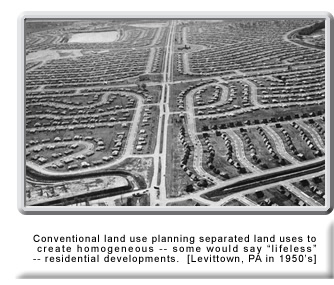 In one respect, conventional land use planning was too successful. The reaction against the incompatible mixture of unplanned land uses resulted in an over-reaction, creating communities where land uses were so completely separated that something important was lost. What was created was the stereotypical post-WWII American suburb, where large tracts of single-family housing are separated from large shopping centers and large industrial and office parks – all very homogeneous and all accessible only by automobile.
 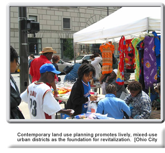 “Planning for diversity” may seem like a contradiction in terms. It might be assumed that diversity “happens” and that planning promotes uniformity. In fact, neither is the case. It is true that some successful, vibrant mixed-use districts grew incrementally, almost organically, without the benefit of planning. However, it is also a fact that many truly abominable places just “happened” – in the chaos of unplanned development. While many residents today value the ability to walk to a neighborhood coffee shop, few are clamoring for auto repair garages or metal stamping plants to open next door to their homes!
 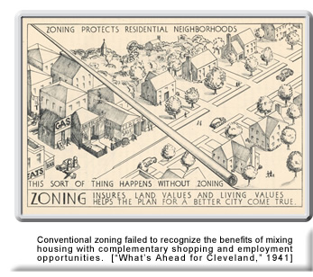 Land Use Planning and Zoning. In the context of comprehensive planning, “zoning” is one of the tools used to implement a plan. Whereas the land use plan is a “guide” for development, zoning is the “law” that regulates development. A zoning code and map, just like a land use plan, reflects certain underlying assumptions about what a community should be. As conventional land use plans promoted the separation of land uses into relatively homogeneous districts, conventional zoning codes were enacted to mandate those development patterns. In fact, zoning was so commonly used to enforce uniformity in development and to exclude diversity that the term “zoning” became linked with the adjective “exclusionary,” as in “exclusionary zoning.”
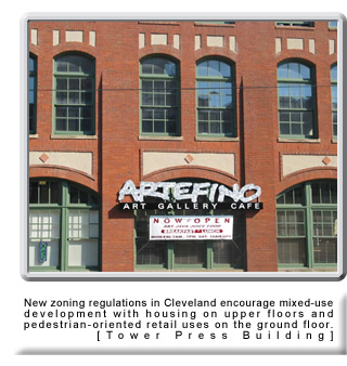 Once the Connecting Cleveland 2020 Citywide Plan is adopted, along with its future land use map, the plan will be implemented by an updating of the City’s zoning map to reflect the new future land use map.